Wednesday, October 24, 2012

Blog #5

Soil Texture Diagram

Munsell Soil Color Diagram

12 Soil Orders of the World
And here is a link to the official government site

Utilsol is the predominant soil type in the state of Georgia.


Monday, October 22, 2012

Blog #4

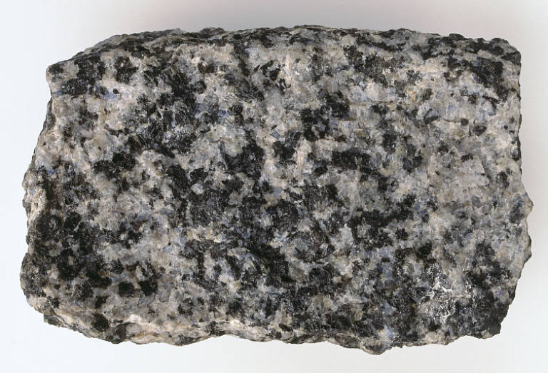
Granite

Most granite is in the SiO2 (silica) form. Granite is a common widely occurring type of intrusive, felsic, igneous rock which is granular and crystalline in texture. This rock consists mainly of quartz, mica, and feldspar. Occasionally some individual crystals (phenocrysts) are larger than the groundmass, in which case the texture is known as porphyritic. A granitic rock with a porphyritic texture is sometimes known as a porphyry. Granites can be pink to gray in color, depending on their chemistry and mineralogy. By definition, granite is an igneous rock with at least 20% quartz by volume. Granite differs from granodiorite in that at least 35% of the feldspar in granite is alkali feldspar as opposed to plagioclase; it is the alkali feldspar that gives many granites a distinctive pink color. Outcrops of granite tend to form tors and rounded massifs. Granites sometimes occur in circular depressions surrounded by a range of hills, formed by the metamorphic aureole or hornfels. Granite is usually found in the continental plates of the Earth's crust.

Gneiss

Gneiss is a common and widely distributed type of rock formed by high-grade regional metamorphic processes from pre-existing formations that were originally either igneous or sedimentary rocks.

Coquina (Shellstones)

Coquina is a sedimentary rock that is composed either wholly or almost entirely of the transported, abraded, and mechanically sorted fragments of the shells of either molluscs, trilobites, brachiopods, or other invertebrates. For a sediment to be considered to be a coquina, the average size of the particles composing it should be 2 mm or greater in size. Coquina can vary in hardness from poorly to moderately-cemented. The term "coquina" is derived from the Spanish word for cockleshells or shellfish. Incompletely consolidated and poorly cemented coquinas are considered grainstones in the Dunham classification system for carbonate sedimentary rocks. Well-cemented coquinas are classified as biosparites according to the Folk classification of sedimentary rocks.

Quartz

Quartz is an abundant mineral in the Earth's continental crust. It is made up of a continuous framework of SiO4 silicon–oxygentetrahedra, with each oxygen being shared between two tetrahedra, giving an overall formula SiO2. There are many different varieties of quartz, several of which are semi-precious gemstones. Throughout the world, varieties of quartz have been, since antiquity, the most commonly used minerals in the making of jewelry and hardstone carvings.

Feldspar

Feldspars (KAlSi3O8 – NaAlSi3O8 – CaAl2Si2O8) are a group of rock-forming tectosilicate minerals which make up as much as 60% of the Earth's crust. Feldspars crystallize from magma in both intrusive and extrusive igneous rocks, as veins, and are also present in many types ofmetamorphic rock. Rock formed almost entirely of calcic plagioclase feldspar (see below) is known as anorthosite. Feldspars are also found in many types of sedimentary rock.


Hornblende

Hornblende is a complex inosilicate series of minerals (ferrohornblende – magnesiohornblende). It is not a recognized mineral in its own right, but the name is used as a general or field term, to refer to a dark amphibole. Hornblende is an isomorphous mixture of three molecules; a calcium-iron-magnesium silicate, an aluminium-iron-magnesium silicate, and an iron-magnesium silicate. The general formula can be given as (Ca,Na)2–3(Mg,Fe,Al)5(Al,Si)8O22(OH,F)2.


Mica

The mica group of sheet silicate (phyllosilicate) minerals includes several closely related materials having close to perfect basal cleavage. All are monoclinic, with a tendency towards pseudohexagonal crystals, and are similar in chemical composition. The nearly perfect cleavage, which is the most prominent characteristic of mica, is explained by the hexagonal sheet-like arrangement of its atoms.


Monday, October 1, 2012

Blog #3

For our third lab, we took a walk around campus and learned a great deal about the trees, shrubs, and flowers that we typically walk past everyday.

Among the scrubs, we saw...

The Loropetalum
This plant is also known as the "Chinese Fringe Flower." It is popular in the southeastern portion of the United States. It grows best in a rich, acid loam that is drained well.

The Itea Shrub
The scientific name for this plant is "Itea Virginica." This scrub is primarily found in the southern portion of the United States. This plant is also known as the "Virginia Sweetspire" and the "Virginia willow."

The Vinca Scrub
This shrub can withstand hot summers, making it great for the southeastern portion of the United States.It blooms early and it is drought tolerant. It is also known as periwinkle.

Among the trees, we saw...

The Cabbage Palm
This tree has a scientific name of "Sabol palmetto." It is also the official state tree of Florida. It can grow very well in many types of wetlands. It is primarily found the the southern portion of the United States.

The Pecan Tree
The scientific name for this tree is "Carya illinoinensis." This tree can be found in the southeastern United States, Ohio, and New Mexico among other places. Thomas Jefferson actually planted Pecan trees. This tree is also the official state tree of Texas.

The Dogwood
It has a scientific name of "Cornus florida." This tree is adaptable to growth in many different soils. It is found in the southeastern portion of the U.S.

And among the flowers, we saw...

The Day Lilies
The scientific name for this flower is "Hemerocallis" The scientif name is derived form two Greek words, meaning "beauty" and "day." These flowers can be drought tolerant when needed.

The Marigold
This flower has a scientific name of " Tagetes." These flowers can have a musky fragrance. They can be a great nectar source for butterflies.

The Verbeana Latana
These flowers are mostly used as ground covers, though they can grow to be six feet tall. They are native to the American tropics. Flowers are born throughout the year in areas that are frost-free.

These plants are some of the plants that make up the environment around the Mercer University campus, as well as portions of the southeastern United States.


Thursday, September 27, 2012

Blog #2

For our second lab, we took a trip to the Ocmulgee River to run some observe the landscape, as well as run some tests in the river. We looked to measure the elevational differences in the different areas along the river bed. We also measured the amount of clams that lived in certain areas of the water. Finally, we measured the flow rate of the river using simple objects.

1. Measuring the elevational differences - We did not get the opportunity to measure the elevational differences However, if we did measure the levels we would have measured the elevational differences by using PCB pipes and reading the line levels that are marked on it. One pipe with markings on it would be tied to another pipe like it. Then you would take the numbers from the pipes and subtract them to get the elevation increase or decrease. One mark on the pipe equals one foot.

2. Measuring the relative amount of clams in river - We used a large crate with a metal screen in the bottom. We dug up some sand from different areas of the river and placed the sand in the crate. Then the sand was sifted through the metal screen, revealing the clams. Then the number of clams was counted and we took counts for different elevations to see the clam concentrations in certain types of areas (ex. deep underwater sand vs. island sand).

3. Measuring the river flow rate - We found a small object to float in the water. Then we spaced people out in even intervals to see how much time it took the object to reach each person. Then the object was allowed to float along the river, passing by the people. Then we calculated the speed by taking the distance and dividing it by the amount of time it took to cover that distance.

Our Ocmulgee River Experience

Ocmulgee River Data

My Ocmulgee River Elevation Graph


So our trip to the Ocmulgee River helped us to see how to measure different constructs by measuring the clam concentrations, the river flow rate, and the different elevational levels of the river. Knowing these things about the river is important because the Ocmulgee River is such an integral part of the environment.


Thursday, September 6, 2012

Blog #1


Cartography

Choropleth Map
The chloropleth map is good for visualizing a measurement's variation across an particular area. In this map we see can see where there are many acres of orchids and also areas that do not have a lot of orchid acres. 

Dot Density Map


The dot density map is useful because they can see spacial patterns of whatever the map looks to show. Each dot should be placed in a pinpoint location. It is also good in showing the concentration of something. For instance, in this map, we can see that the United States' harvested cropland in 1949 was mostly harvested in the Midwest.

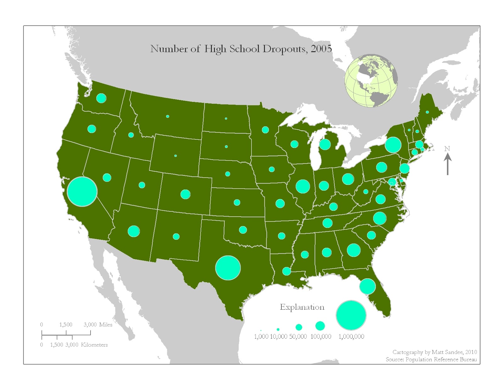
Proportional Symbol Map


The proportional symbol map is used to show geographic information. Symbols on the map are generally not placed in pinpoint locations. In this map, we can see that the larger states have a higher number of high school dropouts.

Isopleth Map


Isopleth maps are good in showing a particular area's steepness as well as weather fronts that may be moving in an area. This map is unique because the lines are the focal point rather than dots, coloration, and symbols. In this example, we can see there are a few steep spots in the area and we can also see the elevations.

This is a link from the Weather Channel about Tropical Storm Leslie